
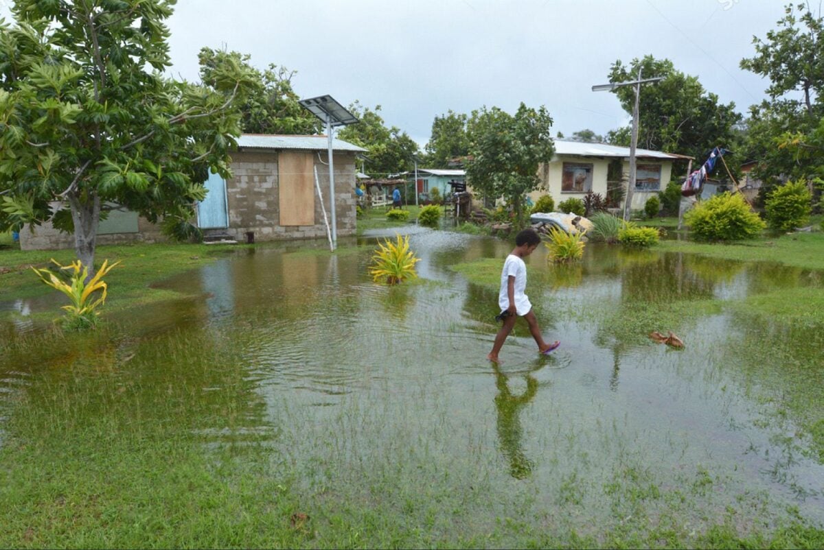
On Saturday, 20 February 2016, Tropical Cyclone Winston, an extremely destructive Category 5 cyclone, struck Fiji.
Cyclone Winston was and still remains the strongest cyclone to hit a country in the Southern Hemisphere, and it devastated many communities across the country. Cyclone Winston had winds of up to 320km per hour and wiped 30 percent of Fiji’s gross domestic product (GDP) off its economy.
Fiji, like most of the Pacific region, is spread across hundreds of islands which span a vast seascape. This reality makes it hard to access remote communities quickly when disaster strikes.
In the case of Cyclone Winston, the path of destruction changed quickly, and areas that were expected to be safe were devastated.
“I had to put my wife and kids in our toilet, I closed them in. I heard them screaming as the winds picked up. I told them to stay put and don’t worry about me. If the house gets destroyed, I’ll save myself. It’s not easy to talk about what we went through on Vanuabalavu during Tropical Cyclone Winston,” said Leveti Sura from Levukana village on Vanuabalavu.
The cyclone impacted more than 540,000 people, equivalent to 62 per cent of the country’s total population. It also brought down power and communications systems, with approximately 80 per cent of Fiji’s population without power and some for many months after the cyclone.
A total of 44 fatalities were sadly confirmed as a result of the disaster, and subsequent access to food became difficult with damage to food crops and agriculture.
Understanding the path of a cyclone at this scale when communications and power are affected is critical for Pacific communities as they face the climate emergency and increasing frequency and intensity of disasters in the future as a result of the changing climate.
In later years, we can observe the classification of the mangroves changing with more areas classified as “closed mangroves” (darker green) and fewer areas classified as “no mangroves”.
In the wake of TC Winston, there is a decreasing area of closed mangroves and an increasing area of no-mangroves
How can the Digital Earth Pacific programme add value?
Digital Earth Pacific will provide a remote tool that can show the path of damage of a cyclone and help map the most affected areas to support the response and recovery teams in their humanitarian and rebuilding activities.
The system further helps us see the changes before and after disasters like this, showing what the real impact has been on coastlines, agricultural crops, housing, infrastructure and water systems. This information provides critical and timely decision-ready products to allow humanitarian teams to act quickly.
With DEP, Pacific leaders can improve their preparedness, disaster response, resource allocation, infrastructure assessment, environmental impact analysis and facilitate international cooperation.
Having accurate data from DEP, before and after natural disasters, will help decision-makers in making well-informed decisions for the betterment and protection of the Pacific communities and nations.
Digital Earth Pacific is a groundbreaking tool that will support countries facing disasters like these in the future.
SPC is thrilled to lead the development of the public digital infrastructure that is Digital Earth Pacific. To achieve the ambitious goals, we invite you to join us. Given our demand-driven approach, partnerships are an essential and major element of DEP. We seek mutually beneficial partnerships to deliver the programme, amplify the benefits, and ensure sustainability.
This story was written by Nabil El Halwani, originally published at SPC on 22 October 2023, reposted via PACNEWS.